Thursday, December 15, 2016
Esri Rolls Out Elevation Data To Monitor Melting Ice, Glaciers In The Arctic
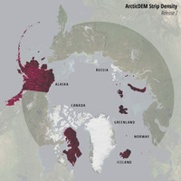 Redlands-based geographical information systems (GIS) software developer Esri said on Wednesday that it has rolled out a new set of data on Arctic elevation, to help monitor melting ice due to climate change in the polar region. According to Esri, it has teamed with the ArcticDEM project, a public-private initiative which aims to produce high-resolution, high quality digital elevation models (DEM) in the Arctic, to release the data. Esri said the data helps provide new insights into the effects of climate change. Digital elevation models (DEM) are used to provide highly accurate monitoring of changes to topography in remote locations. Esri's new models show very detailed surface information on Baffin Island, Svalbard Islands, and Iceland--enough that users can measure the rate of of the glaciers receding, and melting ice, as well as to monitor coastal erosion.